July 9, 2020
“Everyone wants to know when this will end. That’s not the right question. The right question is: How do we continue?” – Devi Sridhar, public health expert at the University of Edinburgh
The COVID-19 pandemic has forced cities around the world to come up with response measures to meet the needs of a changing environment. This includes adapting our public spaces and streets.
As cities seek to keep up with the rapid changes brought by the pandemic and support both local economies and healthy habits, it’s been a time to experiment, using streets as testing grounds for change. This new reality has challenged cities to think about how they can best provide for an increased demand for people walking and biking around neighborhoods while adapting to physical distancing recommendations.
Tactical urbanism is a methodology used to implement quick-build projects aiming to demonstrate through a proof of concept the transformative power of interventions in the public space. It’s been a popular choice to install temporary measures that improve spaces for people, and during COVID-19, it’s been a response tactic to challenges that include:
- Sidewalks being too small to maintain physical distancing
- Increase in vehicular speeds
- Need for safe and accessible bicycle and public transit routes
- Access to public spaces
Tactical urbanism is not about achieving perfection; it’s about implementing impactful interventions that leverage short term action for long term change. As Joshua Pine writes for Strong Towns, “rooting abstract ideas in reality through tangible pilot programs promotes data-centered innovation which enables cities to rapidly and effectively meet the needs of its residents.”
Tactical urbanism is not about achieving perfection; it's about implementing impactful interventions that leverage short term action for long term change.
Across the world in the past few months of COVID-19, there have been a variety of livable streets response strategies, from pop-up bikeways to temporary parklet programs to operational changes at signalized intersections. These strategies are helping residents get comfortable during reopening phases as more people navigate streets at a time when being out in public poses health risks.
As the Broward Metropolitan Planning Organization (Broward MPO) prepares to roll out their own tactical urbanism program, they’ve started engaging with partner agencies to understand how they can best support tactical urbanism efforts in those communities. On June 24, Kittelson supported the Broward MPO in hosting a webinar where representatives from the City of Tampa, City of Charlotte, and City of Fort Lauderdale shared highlights of their COVID-19 response strategies to date. Here is a recap of those highlights.
City of Tampa “Lifts Up Local”
Phased reopening of restaurants and retail in the City of Tampa, FL began on May 4. In order to increase capacity limits from 25% to 50% so businesses could safely serve more patrons, the City of Tampa launched the City of Tampa Business Recovery Initiative, which began as an initial 14-day pilot but is still active at the time of this writing.
An executive order temporarily waived permitting fees and applications to allow restaurants and retail businesses to expand their business footprint onto the public right-of-way or into privately owned parking facilities. Businesses are required to maintain six feet of separation between patrons as well as ADA and other access standards. The recovery plan, branded as “Lift Up Local,” is communicated to Tampa residents through a website and guidebook, along with materials to help businesses focus on hospitality rather than enforcement.
In addition, the City of Tampa implemented a few full street closures, which they refer to as café and retail zones. Locations for these street closures were selected based on clusters of economic activity, safety considerations, and parallel activity. Business hours were modified and restaurants are allowed to sell alcohol in the street closure areas. Social distancing is encouraged through spray chalk art and signage.
“We’re not looking for a party atmosphere. We’re looking for people to sit, eat, and leave,” noted Danni Jorgenson, City of Tampa Chief Transportation Planning Engineer. “This is intended to help restaurants expand capacity. Reservations are required for restaurants participating in use of expanded outdoor space.”
Danni said the project has been a success so far. “We talked to a lot of restaurants who near 100% pre-pandemic revenue and occupancy because of the expansions,” she said on the webinar, noting how the pilot proved the benefits of their Open Streets program.
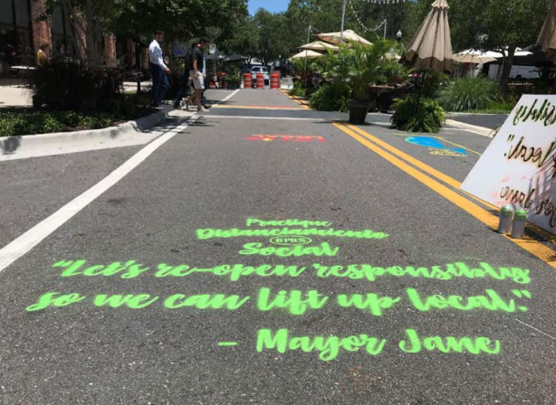
Image credit: City of Tampa
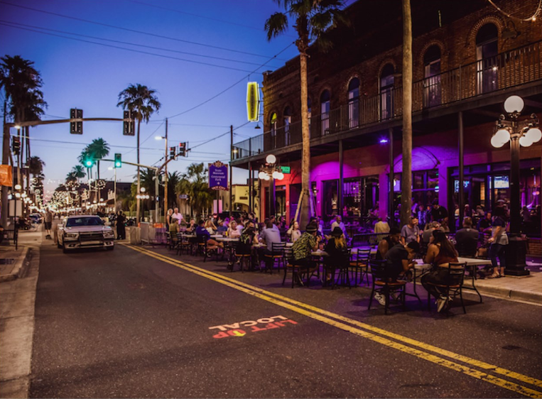
Image credit: City of Tampa
City of Charlotte Raises Spirits With Public Art
Similar initiatives are seeing success in Charlotte, NC. Many neighborhood streets in Charlotte were closed to through traffic to support pedestrian and bicycle activity while encouraging social distancing. The City of Charlotte also created a Streeateries Program that allows for restaurants to utilize parking spaces and extra sidewalks/street space for temporary outdoor dining conversion as long as six-foot separation is maintained, occupancy does not exceed 50%, and bilingual signage is posted. The City decided to do this for a 90-day period and allows for restaurants to apply for permits.

Image credit: City of Charlotte
Taiwo Jaiyeoba, City of Charlotte Assistant City Manager and Director of Planning, Design and Development, noted that evaluation is continuing on a rolling basis, but so far most of the feedback from Charlotte residents is in support of the Shared Streets program and the Streeateries program.
In addition, COVID-19 has brought more art into the streets of Charlotte. The City of Charlotte has had a Placemaking Program since 2018 to support tactical urbanism ideas, one of which has been was inviting art into the public realm.
“It’s one thing to get people out on the street, but make it attractive,” said Taiwo. “Make it vibrant and enjoyable. Colors and pictures and art has a way of lifting the spirit up.”
Local artists from the City’s Placemaking Artist Pool proposed 21 concepts to capture the impact of COVID-19 and the resiliency of the city. In total, 15 murals were painted in 15 neighborhoods, each one 15 feet long, by 15 local artists. Each mural is restricted to one traffic lane and was all funded by the City.
In uptown Charlotte, one very special mural was painted on June 9. 17 artists gathered and worked nearly all day to paint the phrase “BLACK LIVES MATTER” on Tryon Street in the urban center of the city. Taiwo says the mural, known as “The Message on the Street,” has become a major gathering place for the African American community and others who would not typically visit this urban center.
“I personally believe that people are the ones that make cities smarter. If people make cities smarter, cities should also make people smarter,” said Taiwo.
He noted that part of uptown is closed to cars for the foreseeable future. There had already been conversation to shut it down prior to COVID-19, and the community response so far has been supportive of the change. Signs are also posted near the mural to remind residents to maintain safe distances while gathering.
"I personally believe that people are the ones that make cities smarter. If people make cities smarter, cities should also make people smarter."
- Taiwo Jaiyeoba, City of Charlotte Assistant City Manager and Director of Planning, Design and Development
City of Fort Lauderdale Repurposes a Lane on a Beachfront State Road
As the City of Fort Lauderdale, FL began its reopening phases, the mayor formed a working group to think about how to address challenges associated with reopening: specifically, providing safe recreational opportunities and supporting businesses with restricted indoor capacity. The working group was a cross section of 23 community members and stakeholders, including residents, hospitals, hospitality, recreation, construction, and the marine industry.
State Road A1A (SR A1A) runs parallel to the beach in Fort Lauderdale. Lined with resorts, restaurants and bars, SR A1A buzzes with activity most of the year. Every weekend in the month of May, a lane of traffic on SR A1A was closed off using barriers and cones to provide expanded space for walking and biking on the street while promoting physical distancing.

Image credit: City of Fort Lauderdale
This effort took significant coordination with internal departments such as police, fire, parking services, the City’s communications office and with FDOT since A1A is part of the state highway system. This effort also required coordination with a contractor for the maintenance of traffic (MOT) because the City didn’t have all of the needed equipment on hand. Funding was an important consideration for the implementation of the project. The beach in Fort Lauderdale typically has many spring and summer events, for which the City has a fund to manage traffic during these events. The City repurposed the funding for the events that would have happened during this time to use it for this purpose instead.
On the webinar, Mark Plass, FDOT District Traffic Operations Engineer, noted that the closure of SR A1A shows how the period of time we’ve been going through is an opportunity to identify long-term, maybe permanent urban mobility strategies in the future.
“I think there really has been a very holistic effort made to better create a sense of place in areas that maybe didn’t have as much of one as they do now,” said Mark. “It’s kind of ironic to me that it took something like this to get a sense of place created perhaps to a higher level.”
"I think there really has been a very holistic effort made to better create a sense of place in areas that maybe didn't have as much of one as they do now."
- Mark Plass, FDOT District Traffic Operations Engineer
In addition to SR A1A, the City of Fort Lauderdale is supporting businesses on Las Olas Boulevard and 33rd Street, two popular shopping and dining destinations. Every weekend, parking lanes are closed on Las Olas between SE 6th and SE 11th Avenue. 33rd Street has been a full closure, every evening starting at 4:30 in the afternoon.
“In Fort Lauderdale we saw a huge increase in walkers and bikers,” said Karen Warfel, City of Fort Lauderdale Transportation Planning Program Manager. “We were able to provide people that additional space to feel comfortable and get a chance to maybe rediscover their bike again after they hadn’t for a while.”
She concluded with a question: “How do we continue that and make these things more permanent and leverage them as transportation professionals to get support for more improvements? Now people have a better understanding of what the challenges are on our streets.”
The Time Is Now
Although shelter in place orders have ended for the most part, the health risk of the coronavirus is still very real. Summertime, when many people look for ways to get outside, is an important time to implement measures like the ones described in this article to promote a safe environment for those who are walking, biking, dining, and supporting local businesses.
Here at Kittelson, we’ve worked on tactical urbanism projects ranging from transforming parking lots into a new public space in the heart of Downtown Miami, to demonstrating how a five-lane arterial can be narrowed to provide for protected bike lanes and safer pedestrian crossings. This type of work is exciting and rewarding, as it provides us all the opportunity to be creative and respond to ever-changing circumstances to keep our communities moving forward as they respond to immediate needs, and also help envision the type of places they want to be. We would be happy to discuss ideas or challenges specific to your city related with tactical urbanism interventions or quick-build strategies, and invite you to reach out.
Finally, if you’d like to watch Broward MPO’s webinar for yourself, you can find the recording here. Thank you to Broward MPO for having this collaborative conversation and to all of the panelists for their insights! You can learn more about Broward MPO’s Complete Streets program here.