March 23, 2020
Developing Proxy Traffic Volume Estimates During COVID-19 Pandemic Conditions
—
Updated: April 2, 2020
The COVID-19 pandemic has developed so rapidly that there has been very little opportunity for preemptive planning.
Our communities’ responses to the pandemic continue to evolve and have caused abrupt and dramatic changes in travel demand volumes and patterns on all roadways including local, collector, arterial, and freeway facilities. Specifically, travel demand is significantly reduced across all modes and travel patterns have also changed very substantially. These changes are the result of multiple factors such as school closures, restrictions on business operations, and an increased amount of telecommuting.
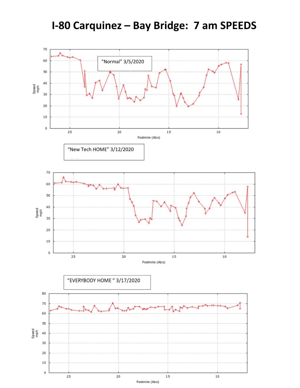
This image, comparing March 5, March 12, and March 17 of 2020, illustrates the remarkable and rapid effects these changes have had on morning peak hour speed characteristics along I-80 across the Bay Bridge in San Francisco, which is emblematic of the reduced travel demand being seen on roadways all across the United States.
The current alternations in travel demand and patterns are ongoing and it is uncertain when a return to normalcy will occur. This raises an important question for transportation professionals: how can important projects that rely on field-collected volume data continue on so that we can avoid, or at least minimize, adverse effects to our productivity and to the larger economy in general?
How can important projects that rely on field-collected volume data continue on?
Our profession has long benefited from sound engineering judgement combined with innovative ideas and approaches, and we are adept in reactive environments where a solution is needed for an unexpected problem. In this case, we can begin by taking stock of the resources currently available to us, and then develop an approach for using them in combination with other tools and techniques to move forward.
Depending on the nature of the specific project being contemplated (long-range transportation system planning, traffic impact analysis, public facility design, etc.), one or more of the following resources will typically be available to transportation professionals even in the current situation:
- Externally-observed traffic data – This includes data collected by the owners, operators, and observers of the transportation system and can include intersection turning movement counts, road tube and automatic traffic recorder (ATR) counts, approach volume counts from some of the more advanced traffic signal controllers, loop detector data, saturation flow rate investigations, vehicle classification studies, etc. Some of these data are archived in large publicly-accessible databases such as PORTAL in the Portland, OR metropolitan area but much of it will be found in disparate locations, files, and documents, such as past traffic studies.
- User-generated traffic data – Connected and probe vehicles are able to provide detailed information on operating conditions by time and location as well as travel patterns and trip generation/distribution characteristics. These data are available through a number of different third-party data aggregators.
These data sources can be used, independently or in combination, to produce reasonable estimates of existing and future traffic volumes under a normal design time period (i.e., non-pandemic) environment. Depending on the age, type, and location of the data it can be converted into reasonable estimates of existing and even future traffic demand volumes through the considered use of historic growth rates, scaling factors, seasonal adjustment factors, directional distribution factors, K factors, and peak hour factors.
The result will, of course, be an estimate, and therefore not an actual new traffic count that we would have otherwise preferred. But there is also ample precedent within the transportation profession for using this type of methodology. For example, the capacity of an intersection and for that matter any component of a transportation facility is almost always estimated based on multiple adjustment factors applied to an initial (ideal) starting estimate. In other words, the methodology being proposed here has a long history of successful use in the transportation profession.
It is also a methodology that benefits from some inherent characteristics of transportation facilities:
- To the extent they are needed, capacity additions usually come in big chunks. The addition of a right-turn lane at a signalized intersection will often increase the hourly capacity of the approach by 700 to 1,200 vehicles. Similarly, the increase in the frequency of arrivals on a bus route from one every 30 minutes to one every 15 minutes can increase the hourly passenger-carrying capacity of that route by as much as 200 people or more.
- The majority (usually 80-95 percent) of the intersections, segments, and facilities in a transportation study area will likely be found to be operating either well under established minimum thresholds (so that no mitigation is necessary) or well beyond these thresholds (so that need for mitigation is obvious). Only a small percentage of the evaluated system components will be found to be operating so close to a triggering threshold that a more accurate estimate is required.
- Because of this, both the need for physical/operational improvements and the effectiveness of those improvements are usually not dependent on a precisely accurate estimate of existing and/or future demand volumes. Where this is not true, a conditional improvement requiring an additional post-pandemic examination can be imposed. To the extent this is needed it will typically affect only a few transportation system components, thereby allowing the overall project to continue on in a productive and economically supportive manner.
The point is: the current inability to collect field data representative of normal conditions should not prevent the continued progression of projects.
We are confident that the resources and tools are available to us as transportation professionals to keep most if not all projects and initiatives moving productively forward, even in the midst of the current COVID-19 pandemic and its consequential effects. The current inability to collect field data representative of normal conditions should not prevent the continued progression of projects initiated by both the public and private sectors. In fact, agencies such as the Clark County Department of Public Works have already released guidance modifying requirements for traffic count data, collection and processing until further notice to meet the needs of these unprecedented times.
White Paper: 4 Steps for Estimating Traffic Volumes Under Traffic-Less Conditions
Our methodology for developing reasonable estimates of existing and future travel demands can be found in a free white paper that was released on April 2, 2020. The white paper can be downloaded below.
For more information, reach out to Chris Brehmer or Marc Butorac. We’d be happy to discuss further.