July 12, 2019
Close your eyes for a second, and think of a city you loved walking through. What do you see and feel?
Traffic whizzing by? Stress from crossing six lanes of traffic in a crosswalk? Tall, uniform, and nondescript buildings?
Of course not. Walkable communities are safe, not stressful; they’re lively, not isolated; they’re connected, not inaccessible; they’re varied and interesting, not bland and sterile.
Creating walkable cities goes far beyond the design of a single corridor – it’s where transportation planning, engineering, architecture, and urban design come together to form a safe, memorable, and equitable environment.
Benefits of Walkability in Cities
The benefits of walkability are many and great. They include:
- Equity: Walking is the cheapest form of transportation and accessible to the largest number of people. Designed well, it can open up access to seniors and people with disabilities.
- Sustainability: Active transportation is also the greenest way to get around.
- Health: According to the 2017 United States Report Card on Walking and Walkable Communities, 43 percent of people who live in walkable areas (meaning they have safe places to walk within ten minutes of home) achieve physical activity targets. Only 27 percent of people who live in less walkable areas achieve physical activity targets.
- Social Benefits: When you’re on foot, you interact with people more, and slow down enough to take in your environment.
- Less Demand on Other Modes: More walking reduces demands on the transportation network for more costly modes, like transit and driving.
- Economic Development: A neighborhood’s WalkScore is a major factor when people look for places to live, work and visit.
- Enjoyment: In his classic 1987 book Life Between Buildings, Jan Gehl notes an interesting walking network has the “psychological effect of making the walking distance seem shorter” because the pedestrian absorbs it in manageable stages (page 143).
What Makes a City Walkable?
When we look at American cities with the highest walk scores, like Boston and Philadelphia, we can identify core elements that contribute to their walkability. For example, both of those cities have infrastructure that offer pedestrians shorter wait times at traffic signals and comfortable or safer sidewalks. They also meet high levels of the following criteria that make them more walkable neighborhoods compared to others:
- Community: Having enough people to support businesses
- Safe Pedestrian Infrastructure: Offering easily accessible transit services, complete streets and safe paths for biking or walking
- Affordable Housing: Providing attainable housing at varying income levels
- Recreation: Centered around shopping districts, parks, and other public spaces
- Commuting: Proximity to schools and workplaces so commutes are accessible by foot
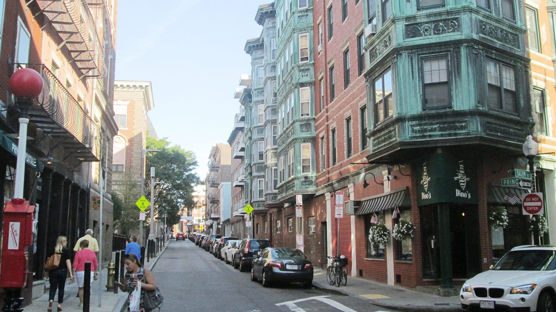
With short block lengths and narrow corridors that are easier to traverse on foot than in a car, Boston is referred to as “America’s Walking City.”
How walkable is your community? Unfortunately, not all cities were designed to be pedestrian-friendly. And generally, the most walkable cities in the world were built before the height of the automobile boom, which has made it difficult for transportation professionals to design a one-size-fits-all solution where cities with varying block lengths perfectly support pedestrians. However, from today’s vantage point, what can we do to improve walkability?
It’s important to ask this question thoughtfully, because every decision creates a ripple effect into the rest of the transportation network. For example, if we make walkability enhancements to a single corridor but more people start driving to get there, we haven’t benefited the system as a whole. The most sustainable and successful strategies are those that take an entire network into account to make systemic changes to street design.
With this mindset, here are five approaches we stand behind.
1. Create and enforce pedestrian-first policies.
Transit-first policies are prevalent in our day and age – and by all means, we are in favor of equitable and sustainable public transit! However, the same mindset has not historically existed for pedestrian policies. Our industry doesn’t currently have good walkability performance measures or agreement on what they are.
Additionally, when we think about how we use language, we quickly realize we aren’t evaluating corridors with a pedestrian-first mentality. For example, we use the term “fail” to describe when a street experiences heavy auto congestion, but in reality, we’re simply evaluating one type of delay over another. Checking our language, agreeing on clear performance measures, and putting pedestrians first in policy design will pave the way for future high-quality pedestrian infrastructure that works in tandem (not competing) with other elements of a transportation network.
2. Target vehicular speeds to support safe and comfortable pedestrian travel.
Exposure to cars is a major deterrent to walking that lowers walk scores. When examining spaces where people are walking, it’s imperative that we address speed limits to cultivate a safer and more comfortable environment. In addition, we should evaluate the needs of the community to determine where people need to walk. For example, are there jobs located along the roadway? Parks? Schools? Shopping areas? Questions like these tend to lead us to areas we should consider when making a community more walkable.
We should evaluate the needs of the community to determine where people need to walk.
Data tells the real stories. And these stories should point us to where speeding needs to be addressed to accommodate safe and comfortable pedestrian use. To see the needle move with Vision Zero, we need to learn from data and set specific performance measures to improve community walkability as well.
Many cities have implemented traffic calming programs to reduce mid-block speeding. What’s important at this stage is measuring results and seeking objectives that understand if these programs are successful. Initiatives like SFMTA’s traffic calming handbook provides more objective methods of understanding large-scale change and program effectiveness.
SFMTA’s traffic calming handbook provides objective methods of understanding the effectiveness of their traffic calming program.
3. Make communities walkable by improving the first mile/last mile connection.
Improving walkability citywide is largely determined by how well walkable spaces interact with other forms of active or sustainable transportation. For example, better walkability around public transit stops makes transit more accessible and increases the likelihood of someone choosing to start or finish their trip on foot. In the City of Lynn, Massachusetts, community members voiced concern that resources and destinations within and around their city were difficult to reach.
Kittelson supported the city by developing a blueprint for a walkable path to the town center. The Lynn Walking and Bicycling Network Plan now connects their town with the ten-mile Northern Strand Community Trail, transforming a shared-use path previously cut off by a commuter rail line into an equitable resource that activates shops, neighborhoods, and public amenities. In this case, the trail already existed, but the valuable last-mile connection with the town will significantly increase accessibility and walkability in both directions.
4. Apply the elements of imageable places to design walkable environments.
In their 2009 study “Measuring the Unmeasurable: Urban Design Qualities Related to Walkability,” Reid Ewing and Susan Hardy wrote about the influence of seemingly subjective urban design factors on a street’s walkability. One of the urban design factors they name is imageability, which corresponds to what we know today as a “sense of place.” A highly imageable city is distinct and instantly recognizable to anyone who has visited or lived there. It plays to the human ability to detect and remember patterns.
Jan Gehl explains imageability using the example of famous Italian city squares, where “life in the space, the climate, and the architectural quality support and complement each other to create an unforgettable total impression” (page 183). A combination of factors makes a space an enjoyable place to be; they include:

Urban designs that contribute to walkability
- number of people
- proportion of historic buildings
- number of courtyards, plazas, and parks
- presence of outdoor dining
- number of buildings with non-rectangular silhouettes
- noise level
- number of major landscape features
- number of buildings with identifiers
5. Look for ways to make people stop walking.
Yes, you read that correctly. It’s said you can measure walkability by counting the number of people on the street who are sitting or standing still.
When you see people sitting at an outdoor café, conversing with one another, or stopping to snap a photo, you know you're in a highly walkable (and imageable) community.
Ewing and Handy remark that the significance of people and outdoor dining suggests human activity may contribute as much to the perception of complexity – making a place feel dynamic and alive – as do physical elements such as street furniture, signage, and diversity of building ages and styles. Urban design has an important role to play here. Bringing human activities outside the walls of buildings (such as benches and outdoor seating on sidewalks) adds dynamism to the street and contributes to the perception that this is a good place to slow down and spend time.
Continuing the Conversation About Making Cities More Walkable
As we noted, much literature exists on this topic already, and there is lots more to say. What have you been reading or learning about walkability? What strategies are working well in the streets where you live, work, and play? Reach out to us to keep the conversation going! Every community has unique needs, and our passion is helping our clients listen well, collect good data, and understand what specific measures will make a positive difference.