February 1, 2023
Water is an essential element of life. It makes our street trees grow tall, it collects in bodies of water that can transform a space into a place, and it heats beautifully in transportation professionals’ coffee makers as we prepare for a day of making roadways better, safer, and more connected. But water also makes our job as transportation planners and engineers really challenging.
Water causes all sorts of problems, ranging from the mildly inconvenient pothole at the end of the driveway to life-threatening floods and landslides. This article is an aquatic exploration of some of water’s more notorious impacts to roadways past and present and how we can work with water, rather than against it, for a more resilient future.
Mud
Long before we had paved roads, water wreaked havoc on human efforts to get from A to B. American roads in the late eighteenth century lacked nearly all of the features necessary for efficient, dry travel: grading, topographical contours, surfacing, and drainage. Many of them even had tree stumps, chopped just below wagon axle height. According to Ann Norton Greene, author of Horses at Work, water-logged roads would suck down horses’ hooves, making each step more taxing for the horse and ultimately reducing the distance and speed at which they could travel. In the early 1880s, Eureka Springs, Arkansas got its first main street. At low elevation and built along a creek, the roadway was so chronically wet that locals nicknamed the street “Mud”.
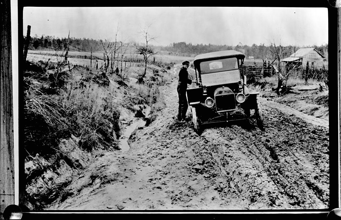 Without grading and drainage systems to shunt water away from the roadway, these soggy conditions prevailed through the nineteenth and twentieth century, and took time to catch up to the automobile, as this 1909 photo taken from southeast of Raleigh, North Carolina reveals.
Image: An early automobile sunk deep in thick North Carolina mud. Source: Albert Barden, “Auto Stuck in Johnston County Mud 1909,” from the Albert Barden Collection, State Archives of North Carolina, Raleigh, NC
According to the Federal Highway Administration, even in 1960, more than 65% of the nation’s public roads were unpaved. Today, it’s closer to 30%. And increased pedestrian traffic and muddy streets are a bad match. When paving wasn’t feasible or desirable, towns and cities often turned to boardwalk stretched across wide downtown streets. The elevated platforms carried people and pets up and away from the mud. These original raised crossings functioned similarly to those we install today: they helped make crossings more visible to drivers and forced carriages and cars to slow down.
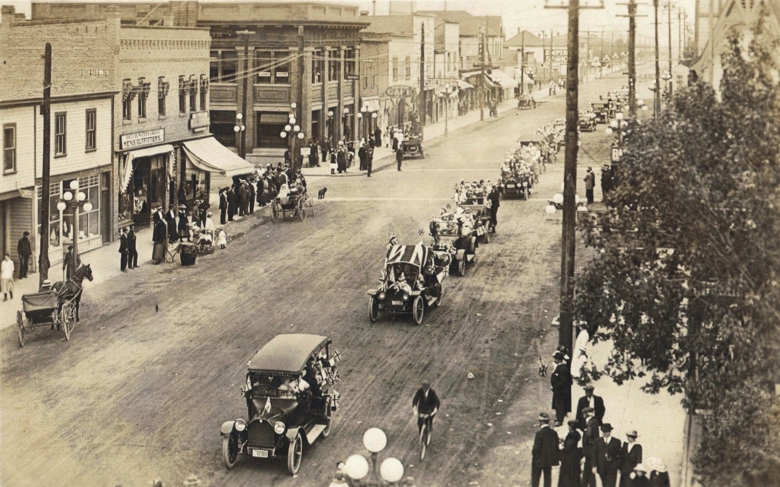
Raised plank crossings in this British Columbia town helped keep pedestrians (and in this case, a small dog) up and out of the dirt road. Source: May Day, May 11th, 1917, Kamloops, BC.
In clear recognition of the mud crisis, a 1908 manual on roads and pavements offered detailed advice on ways to manage water, arguing that better roads would improve the congestion that results from drivers taking advantage of the good season for travel: times when roads are not impassable due to water in the form of snow, rain, or mud. In addition to abating congestion, this manual argued that better (i.e., dry, unrutted) roads would also improve leisure, neighborliness, civic participation, community engagement, educational opportunities, and even church attendance. It offered advice on where to situate drains along the roadway (either in the center or to one or both sides), depending on local soil types and topography, and it set standards for the crown of the road: too high and water will form in longitudinal hollows made by concentrated traffic; too low and water will pool in small depressions and soften the roadbed.
Potholes
Anyone who has spent time in a state that freezes knows the dreaded thunk of a fresh pothole kissing the tires of your car come spring.
The pothole lifecycle begins when rain or snowmelt seeps through cracks in pavement into the sub-base below. If the water isn’t drained away, it freezes and thaws through the seasons. The hydrogen bonds in liquid water are irregular and grouped close together. But when water freezes, the hydrogen and oxygen molecules form hydrogen bonds in a six-sided lattice structure. This extra space in the crystal structure makes water expand by as much as 9% when it freezes. Water that freezes and thaws beneath roadway pavement, pushes against the asphalt and creates a hollow space. When a heavy vehicle then drives over the new void, the pavement crumbles and a pothole is born. A similar process occurs in warmer states when consistent rainstorms erode away poorly-constructed foundation materials underneath the road.
Managing potholes is a time-consuming and expensive endeavor for local and state departments of transportation. Seattle DOT’s Pothole Rangers filled more than 35,000 potholes in 2017. (You can watch the Pothole Rangers in action here.) In Chicago, pothole teams work every day and also weekends during “pothole season”. The Portland Bureau of Transportation maintains a pothole map, where residents can check to see whether a pothole has been reported or fixed. The City of Boston uses an app called Street Bump to crowdsource pavement condition using cellphone accelerometer and GPS data. The City of Eugene’s street repair crews apply more than 20 tons of tar sealing material to local roadways each year.
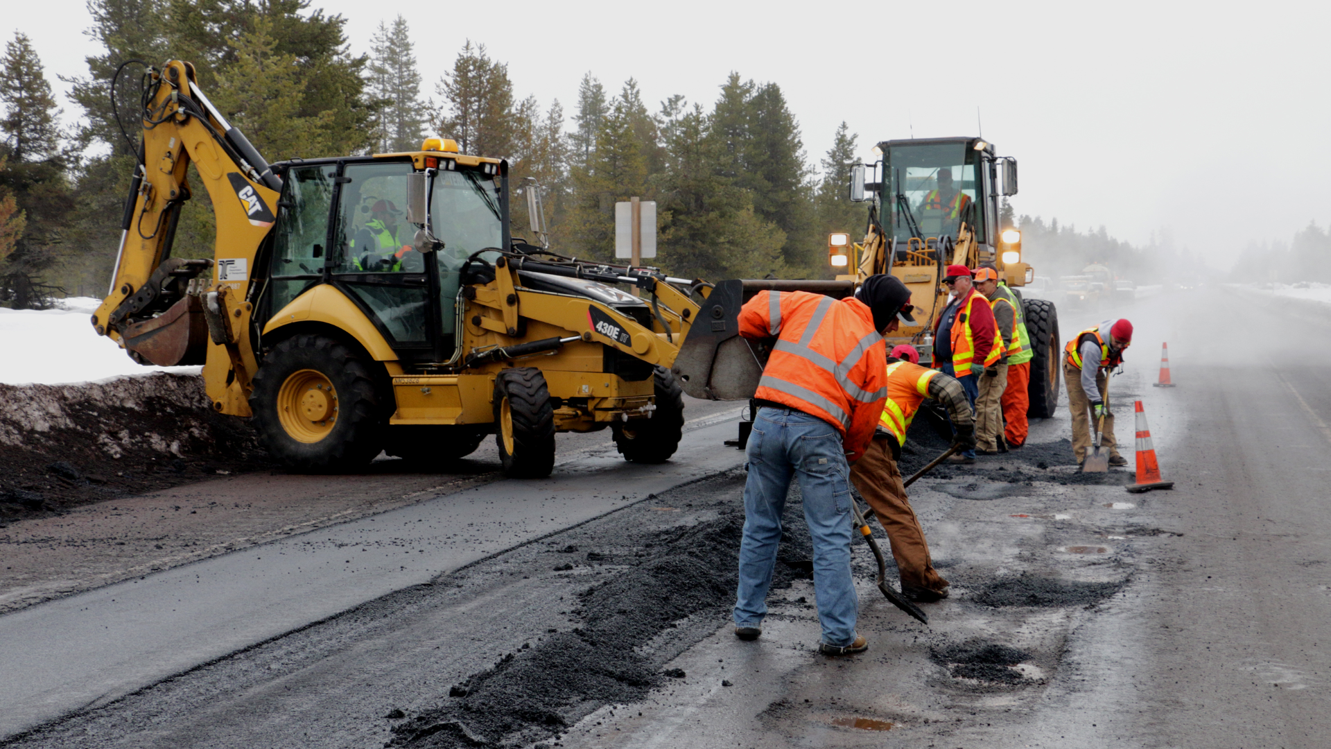
Caption: Oregon Department of Transportation crews fill potholes on U.S. 97 near Chemult, OR. Credit: Oregon Department of Transportation, https://flic.kr/p/D5LbKu.
The best way to manage potholes is keep pavement in tip-top shape, but funding for many agencies is tight and there’s a lot of infrastructure to repair. To get ahead of the next generation of potholes, we can plan pothole-proof streets. Many neighborhood alleys are small pothole cities, according to NACTO’s Urban Street Design Guide. These potholes and puddles make alleys “uninviting or unattractive.” Instead, we can turn to Green Alleys, which “use sustainable materials, pervious pavements, and effective drainage to create an inviting public space for people to walk, play, and interact.” Plus, because increased traffic volumes and more heavy trucks on the road exacerbate pothole formation, the more walkable and bikeable neighborhoods we can create today, the fewer potholes we’ll have tomorrow. (Our cars will thank us).
Runoff, Ponding, & Flooding
Rain, snow, and major weather events like thunderstorms and hurricanes dump water onto our roadways. Along the road, the water picks up trash, bacteria, salts, oils, heavy metals, and other pollutants that it carries into our sewers and streams. Water pollution is detrimental to humans and native wildlife and negatively impacts health, economies, and recreation. When roadway systems rely on traditional sewer systems that lead to local waterways, it funnels this polluted water-which is often warmer and traveling at faster speeds-straight into waterways, blast eroding banks and harming delicate ecosystems.
When too much rain falls for pavement or planted systems to accommodate, waters can rise rapidly and pick up speed. The force behind these floods can wash out bridges and destroy roads. And fast-moving water is strong. Just one foot of rapidly-flowing flood water can carry away most cars, and two feet can wash away large SUVs and trucks, according to the National Weather Service. Wildfire-scorched earth becomes hydrophobic when burned plant matter coasts soil particles in a waxy substance. When heavy rains occur after a fire, this hydrophobic soil takes in less water and is easily carried in debris flows. A type of landslide, these flows can be catastrophic for communities in their path.
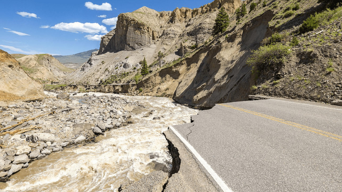
In June 2022, heavy rain and snowmelt washed out roads in Yellowstone National Park. Parts of the park saw up to 9.5 inches of combined rain and snowmelt in a 24-hour period.
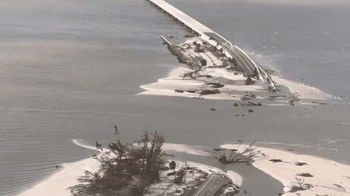
Hurricane Ian wiped out sections of the 3-mile-long causeway that connects Sanibel Island to the Florida mainland in September 2022. Residents were cut off from the island for three weeks due to the damage.
One of the most successful ways to divert stormwater off our roadways is to think green and let water do what water does best: nourish life. Green infrastructure uses soils, plants, and permeable pavements and materials to collect or reuse stormwater. Green stormwater management practices are critical for recharging underground aquifers and ensuring there is enough safe and clean drinking water.
Pervious pavement has gaps that allow water to seep through the roadway material, whether that’s asphalt, concrete, or interlocking or grid pavers. This type of pavement is especially effective in places with significant rainfall. For example, to correct a section of History Street in Melbourne, Florida, we installed pervious pavers that drained stormwater and stored it in a thin retention area under the roadway until it could be absorbed back into the ground.
Rain gardens, planter boxes, and bioswales are planted spaces next to roadways or parking areas that collect rainwater runoff from buildings, streets, and sidewalks. Layers of soil and rock helps drain water away from the roadway and flowers, shrubs, and small trees pull water up from their roots and use it for photosynthesis, the process that sustains plant life by combining carbon dioxide from the air and hydrogen monoxide (water) from the soil. Oxygen is the handy byproduct of this process, which helps improve ambient air quality. As they suck the water up from their roots, many plants pull pollutants out of the soil and water, in a process we call phytoremediation. Some species of moss can even pull lead and arsenic out of water. The surface area of their leaves, especially for evergreen species with dense needles like pines and cypresses, help trees trap airborne particulate pollutants.
Engineered or constructed wetlands use larger areas of marshy land to store water and grow an aquatic ecosystem that can uptake and filter stormwater and runoff. There are two main types of engineered wetlands that differ based on how the water moves through it. The first type sends water below the surface, flowing either horizontally or from top to bottom through the roots of the plants. The second type sends water along the surface, where UV rays from sunlight help kill waterborne pathogens. Depending on location, engineered wetlands can also function as a placemaking feature for a community, with trails, educational signs, and native wildlife habitat.
The real star of the engineered wetland, however, is its varied pool environment. Permanent pools create anaerobic conditions that allow certain microbes to thrive and breakdown common runoff pollutants. Shallow pools foster plants that help uptake and filter pollutants too. The biological complexity in these aquatic environments is what makes engineered wetlands so successful.
When it comes to building engineered wetlands, we may be able to take a back seat to some surprising subconsultants. Enter the beaver. In her book Beaver Land: How One Weird Rodent Made America, Leila Philip writes of a conversation she had with a stormwater engineer while standing before a ten-acre beaver pond. Surveying the vast structure, the engineer tells her that a human-constructed stormwater management pond that big would come with a price tag of $1-2 million.
And beaver dams do more than collect water-they filter it. According to new research by Stanford University, beavers and the dams they build with gnawed bits of trees can counteract water quality degradation brought on by climate change. With warmer, dryer summers, the American west will see water quality declines as ratios of contaminants and extra nutrients rise. In this serendipitous experiment, a beaver built a dam across a study site, so the team was able to record the impact of just one beaver, whose dam improved nitrogen removal in the stream by 44%.
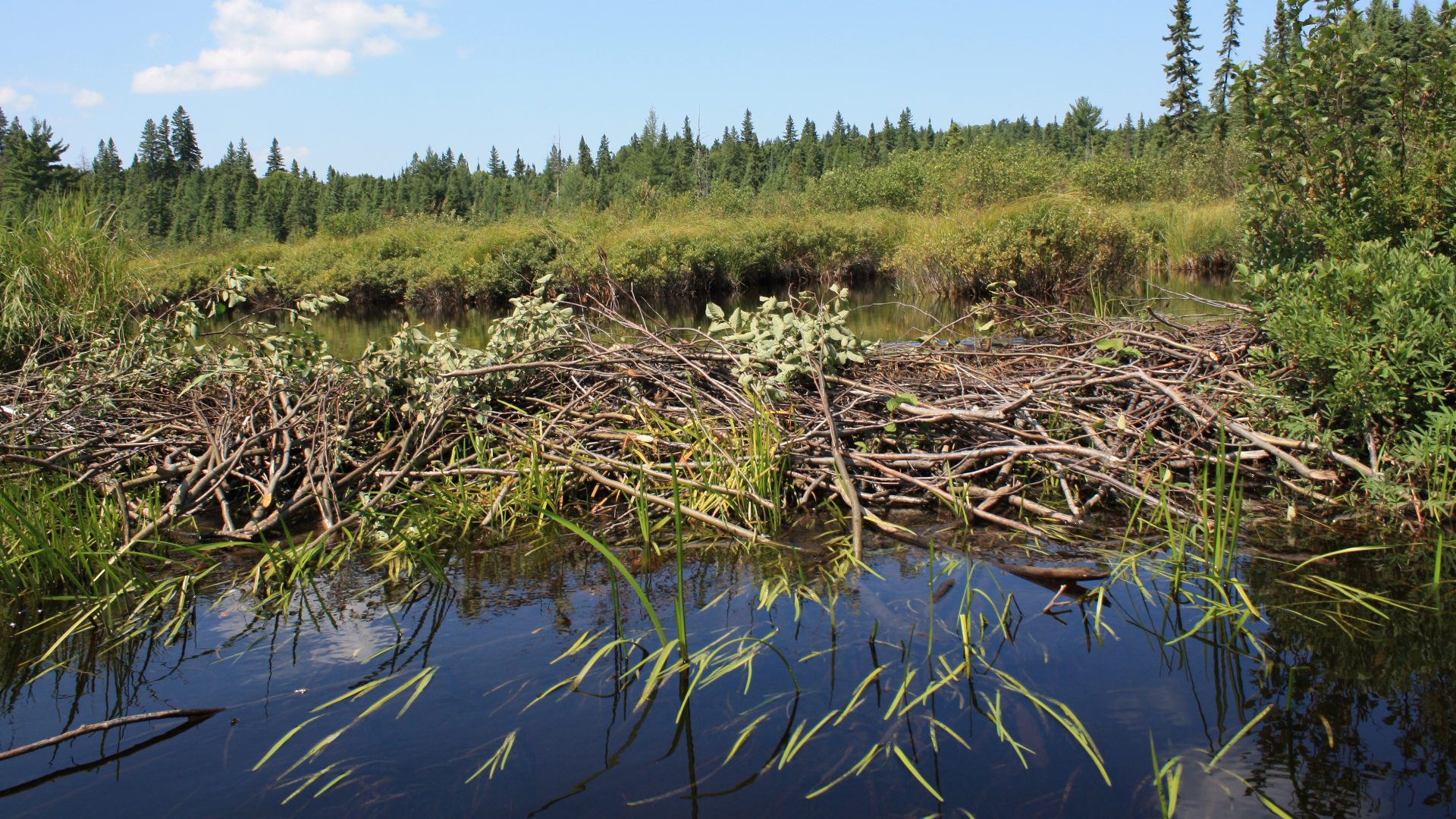
When it comes to building engineered wetlands, we may be able to take a back seat to some surprising subconsultants. Pictured: a beaver dam and pond in Algonquin Park, Canada.
With aging infrastructure and climate change, our industry will be busy as beavers in the search for natural and technological solutions that will meet the demands of our multimodal transportation system and the inevitable-and vital-presence of water.
At Kittelson, we know the importance of planning and designing roadways with stormwater facilities that protect and enhance water quality and our natural resources. Our stormwater engineers work alongside transportation engineers and planners to provide expertise in urban hydrology and hydraulics, water quality treatment, flood mapping, and green stormwater infrastructure. This partnership helps us build and maintain transportation networks that provide environmental protections, comply with regulatory agencies, and contribute to overall quality of life. If water on the roadway is giving you a hard time, we’d love to help!
Image Sources
Albert Barden, “Auto Stuck in Johnston County Mud 1909,” from the Albert Barden Collection, State Archives of North Carolina, Raleigh, NC, https://www.flickr.com/photos/north-carolina-state-archives/46977239112/in/photolist-2ezdCwu-RVAJCG-RVAJEf.
May Day, May 11th, 1917, Kamloops, BC. View looking west from the 400-block of Victoria Street towards the intersection at 4th Avenue, https://www.flickr.com/photos/45379817@N08/18837194233.
Oregon Department of Transportation, https://flic.kr/p/D5LbKu.
Yellowstone National Park, 2022, https://www.flickr.com/photos/yellowstonenps/52156165036/.
Lee’s County Sheriff’s Office, September 2022, https://commons.wikimedia.org/wiki/File:Sanibel-causeway-destruction.webp.
Franklin Vera Pacheco, Wikimedia Commons, 2009, https://commons.wikimedia.org/wiki/File:AlgonquinBeaverDam.JPG.