April 22, 2026
Our planet is full of special places. The depths of the Mariana trench, where all sorts of otherworldly creatures have found ways to thrive. The Galapagos Islands, where iguanas take to the sea and tortoises live more than two human lifespans. The Namib Desert, where a species of beetle survives by collecting fog droplets on its wings.
We like to learn about and visit these special places because there, we get to encounter the sublime otherness of the natural world, an experience that speaks both to our own humanity and our place in the cosmos. But increased pressure from warming global temperatures—which worsen storms, extend and intensify fire seasons, and cause sea level rise—are threatening the plants, animals, and people who call these special places home.
Two extraordinary places—Sanibel Island, Florida and Summit County, Colorado—offer models for how transportation professionals can strengthen communities under threat from environmental stressors. Because it turns out, we can do a lot. Our efforts to shape planning, asset management, emergency operations, and reconstruction design can help special places plan for and recover from natural disaster.
A Tale of Two Communities
On the surface, Sanibel Island and Summit County don’t have much in common. One is a sandy barrier island 12 miles long and just a few miles wide that sits 4 feet above sea level. The other is more than 600 square miles of mountainous land that sits nearly 9,000 feet above sea level at its lowest point. One faces its largest threats from water, the other from fire.
Despite these geographic differences, Sanibel and Summit County share a lot. Both places are major destinations—locales people want to visit to experience something about nature. People visit Sanibel for its serene beaches, world-renowned sea shelling, and the J.N. “Ding” Darling National Wildlife Refuge. Outdoor enthusiasts flock to the mountains of Summit County for snow sports in the winter and hiking and biking in the summer. Early summer wildflowers and fall’s golden aspens are big draws.

Sanibel Island’s sprawling beaches draw vacationers, snowbirds, and conchologists year round. Source: Adobe Stock
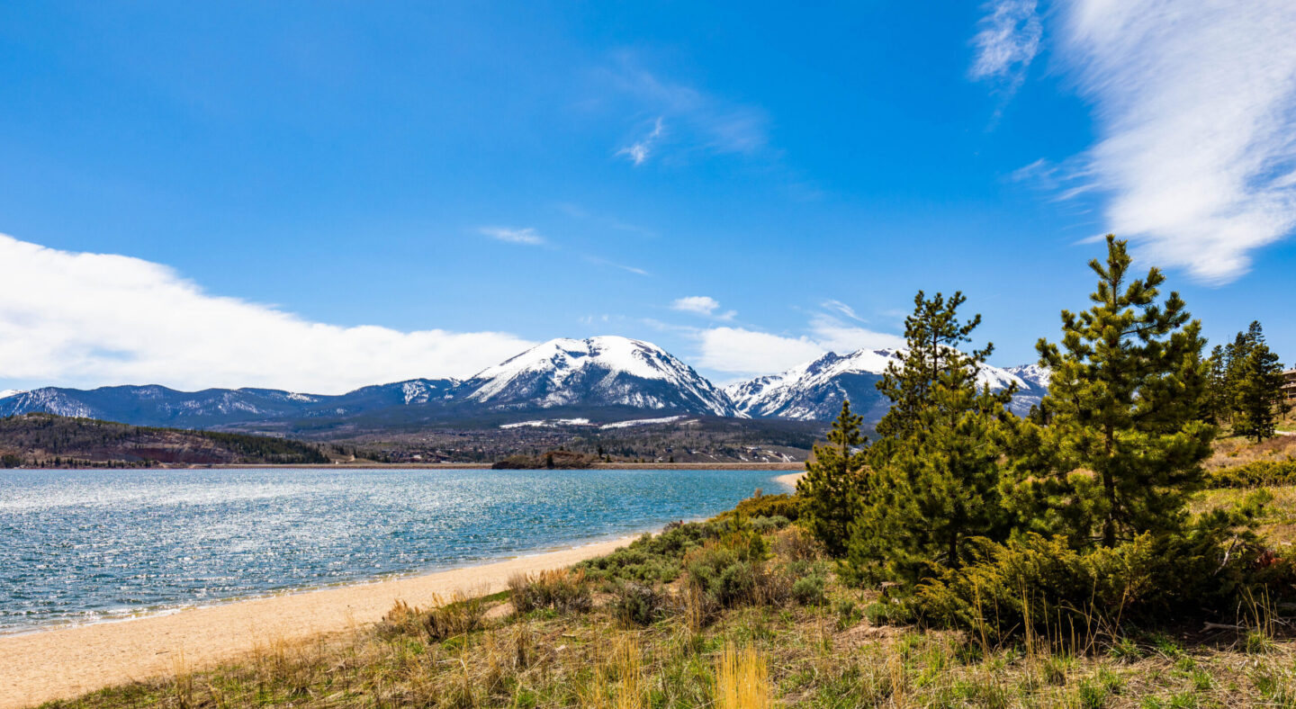
The Dillon Reservoir in Summit County draws tourists for hiking, sailing, and fishing in the summer and cross-country skiing in the winter. Photo source: Adobe Stock
Both places are also home to thriving communities with streets and business districts and many residential homes. On Sanibel, residents and tourists alike have enjoyed generations of pedaling their way along dozens of miles of bike paths, stopping for groceries at Bailey’s General Store or going all the way to the Bailey-Matthews National Shell Museum and Aquarium. Iconic restaurants like the Mucky Duck and the Key Lime Bistro on neighboring Captiva Island are tourist favorites. In Summit County, people frequent historic main streets in Frisco and Breckenridge and dine al fresco in the summer.
But these scenic and vibrant pockets of the country are also made similar by their vulnerability to environmental threats—and their adaptability and proactivity in the face of them. On the Gulf Coast of Florida, Sanibel Island has experienced devastating impacts from hurricanes that have only been intensifying in recent years. The state and city not only responded with swift recovery efforts, but they also strengthened the island’s transportation system against future hurricanes.
Summit County hasn’t experienced a disaster of the magnitude that Sanibel has, but its focus on protecting against climate risks is similar. With its hot, dry summers and wildfire seasons that are beginning earlier and ending later, the County is putting preventative measures and evacuation plans in place. Their stories model how two communities facing parallel challenges can take action to preserve the special places we know and love.
Sanibel Island: Recover & Rebuild
In September 2022, Hurricane Ian walloped Sanibel and neighboring Captiva with winds over 130 mph, inundating the island community with more than 12 feet of storm surge (the unusual rise in seawater during a tropical storm or hurricane). Ian damaged roads and bridges, washing away 50–60 feet of the Sanibel Causeway, a three-mile span that connects the two islands to the mainland. The storm also damaged sanitation lift stations, powerlines, and piers.

Hurricane Ian washed away sections of the Sanibel Causeway, a critical lifeline between the island and the mainland. Source: Petty Officer 3rd Class Riley Perkofski, U.S. Coast Guard.
Immediate infrastructure loss instigated a cascade of economic injury: Ian is estimated to have caused a 40% decline in annual toll transactions, a 96% decline in tourist payments, a 66% decline in annual beach parking fees, and an 81% decline in annual dwelling rental fees.
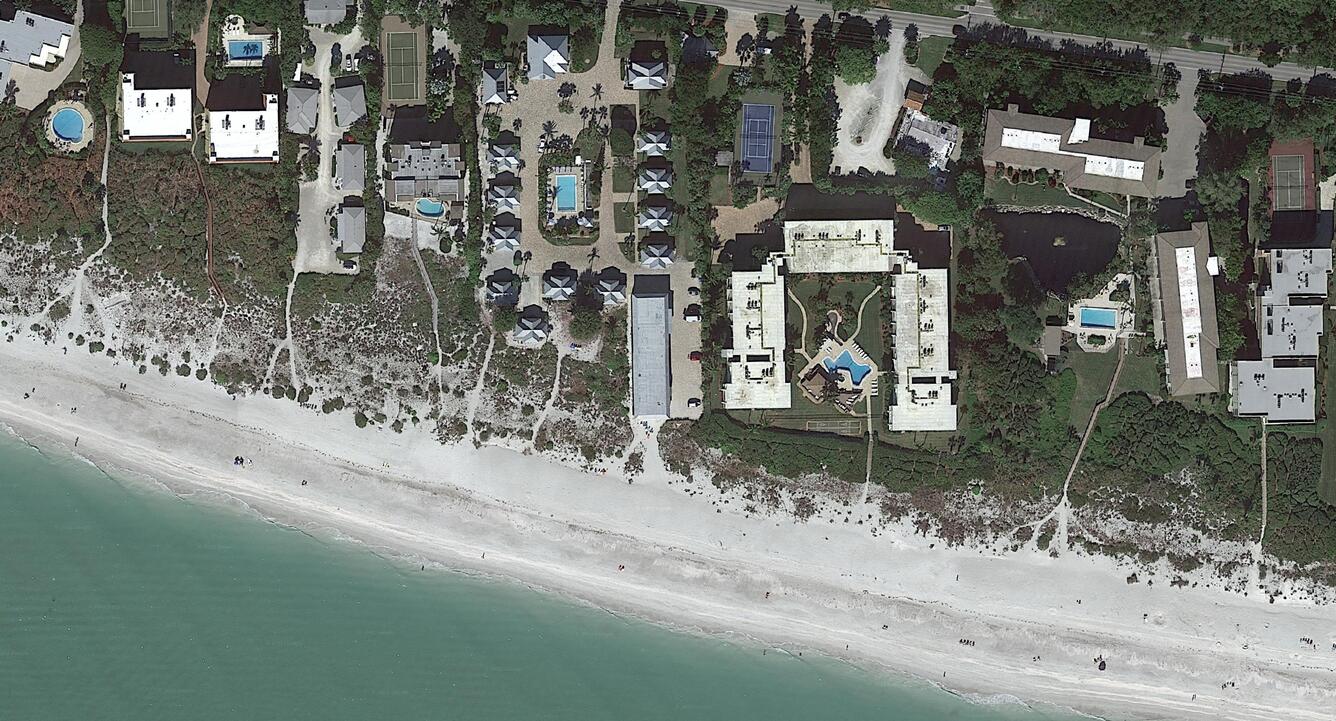
A neighborhood on Sanibel Island before Hurricane Ian. Source: United States Geological Survey
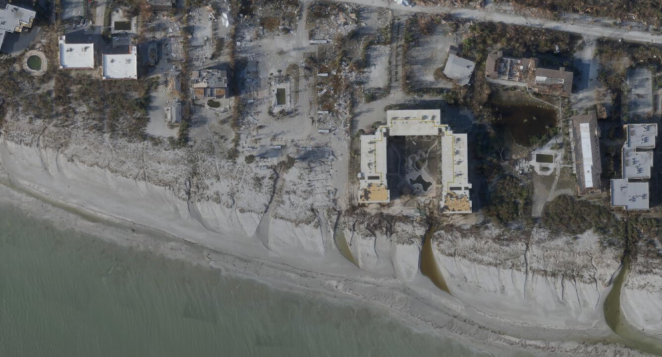
The same neighborhood after. Source: United States Geological Survey.
Sanibel faced a daunting recovery effort. The morning after the storm, residents faced mountains of debris, flooded buildings, broken community assets—and no access to the mainland. To support this beloved Florida community, the Florida Department of Transportation (FDOT) pulled off a small miracle, opening a temporary roadway along the causeway just three weeks after Hurricane Ian collapsed and washed major sections of it away. Today, the fully repaired causeway has a road surface that is 2 feet higher, with layers of protective sheet pile walls to protect the roadway and bridge approaches and marine mattresses to absorb wave energy.
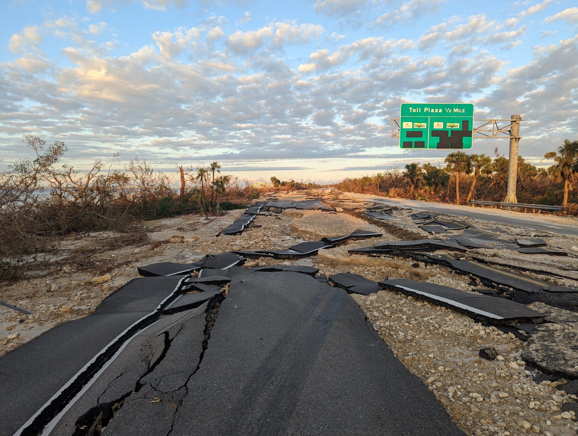
Damage to the causeway after Hurricane Ian. Source: Florida Fish and Wildlife.
To get the bridge up and running, FDOT implemented an emergency phased design-build contract, which allowed the selected construction companies to do emergency repairs and permanent fixes at the same time. Another important reason FDOT was able to so quickly get the bridge reopened is the department’s extensive effort to understand transportation system performance. FDOT’s work to collect data on seaport impacts, airport closures, and construction materials for hurricane preparation and recovery allow it to quickly and effectively mobilize resources. The state also has Emergency Operations Centers all over the state that can be activated during an emergency.
Island-side after Hurricane Ian, instead of rebuilding the community exactly as it was, the City of Sanibel is working to restore the island’s character and prepare it for future storms. The City is prioritizing projects to restore beaches, upgrade wastewater systems, construct a new public safety facility, restore roadways, and study renewable energy sources. Improvements include a full redesign of the East Periwinkle Bridge for long-lasting infrastructure and walking and biking facilities, solar panels on buildings to protect against power loss during storms, water main hardening, and beach dune restoration.
The City adopted dozens of ordinances to remove barriers for residents and business owners to repair and rebuild. Across the island, homes are being elevated so that future storm surges can pass safely under houses.
Sanibel is a great success story of what one community can achieve in the face of great environmental adversity. But Sanibel is not the only community working to reinforce its future.
Summit County: Plan & Protect
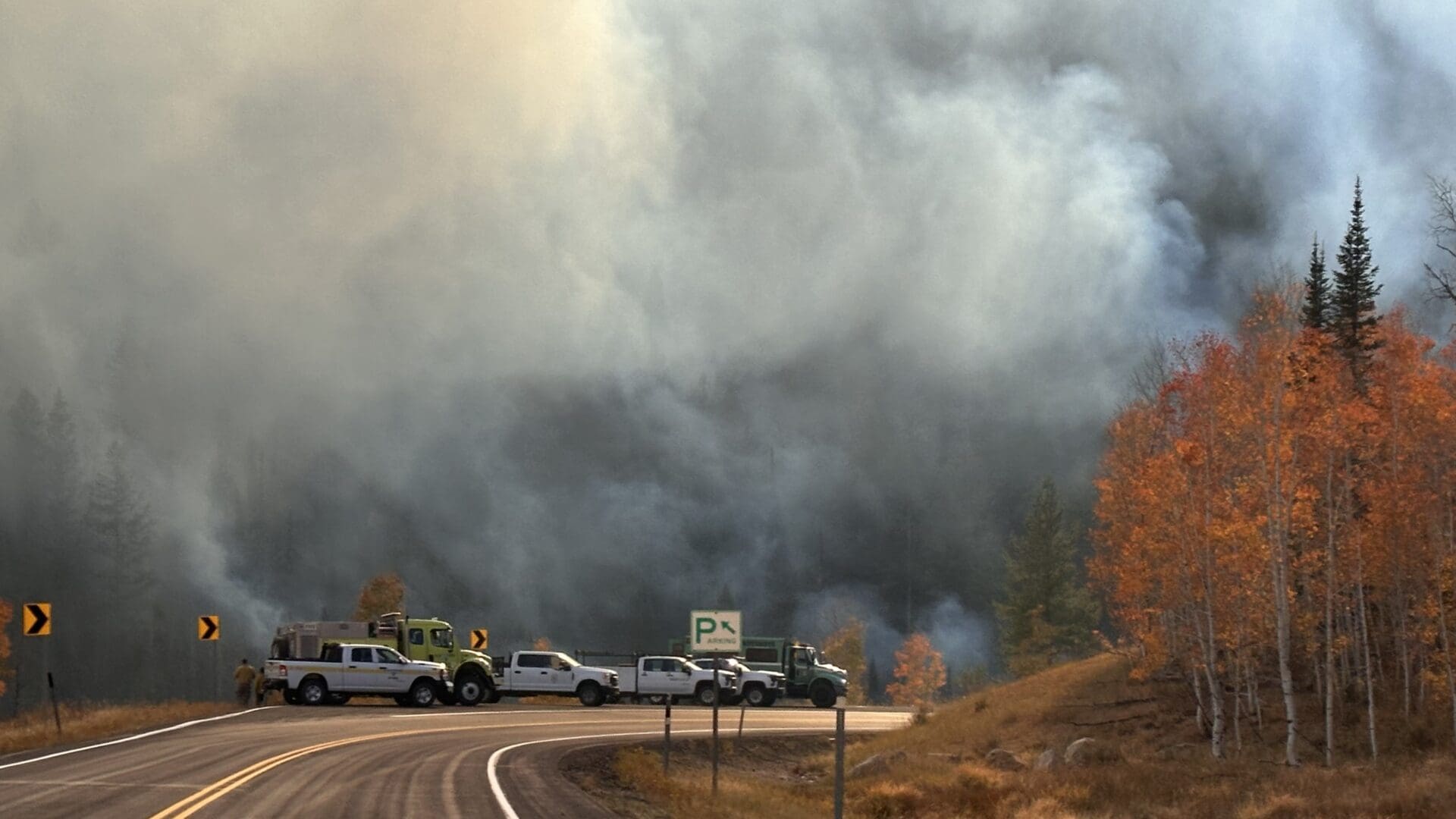
Summit County, Colorado, has experienced many fires—fortunately, none akin to the catastrophic 2021 Marshall Fire. Taking steps to prevent fires from striking a similarly vulnerable area, Summit County has become a leader in community wildfire protection. The County has wildfire mitigation grant programs and offers defensible space assessments, and it has helped protect more than 11,000 homes by chipping 37,000 slash piles of flammable brush. Such attention to wildfire risk is warranted, as climate change has exacerbated the region’s fire risk by prolonging droughts, elevating the heat index, drying out vegetation, and extending fire season.
Evacuations in places like Summit County are not simple. The county’s mountainous topography limits the number of routes in and out, and many destinations—trailheads, campgrounds, short-term rentals, and remote neighborhoods—can have limited connectivity and communications. Summit County’s evacuation challenges are compounded by its position as a prime vacation destination: longer, hotter, and drier fire seasons coincide with peak recreation periods, when tens of thousands of visitors who may be unfamiliar with the road network visit the area.
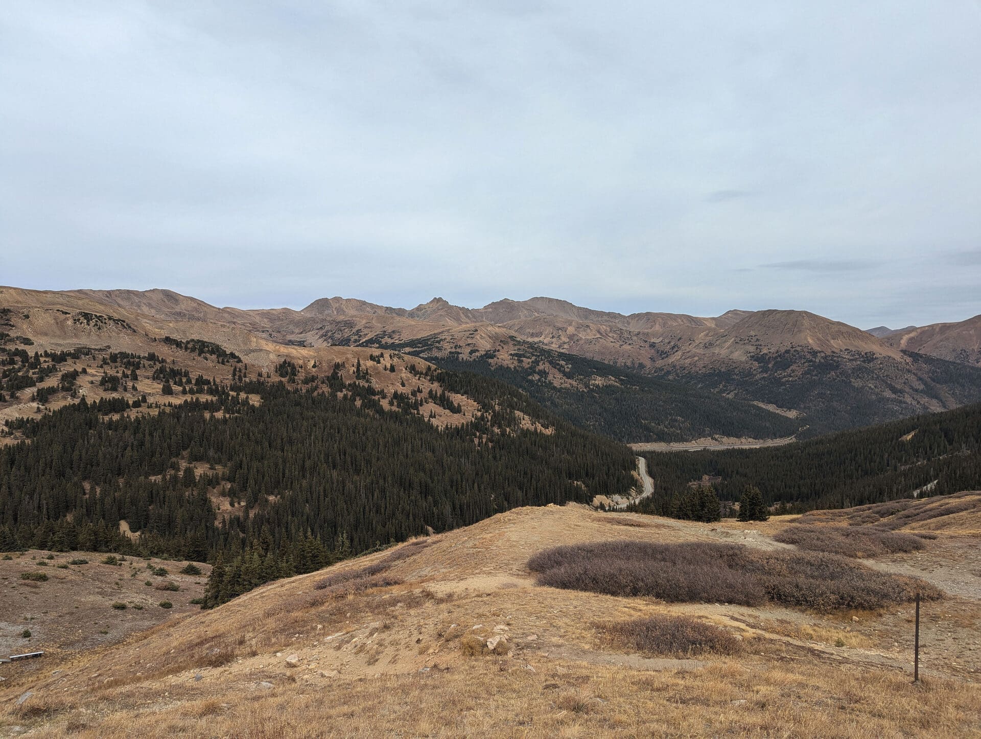
Climate change has exacerbated the Summit County’s fire risk and by prolonging droughts, elevating the heat index, drying out vegetation, and extending fire season. Source: Grace Carsky, Kittelson & Associates, Inc.
To support emergency evacuations in this complex area, we’re working with Summit County to assess the region’s wildfire risk and model how the roadway network might function during simulated fire scenarios. The outcome of this work will be roadway treatments and community programs that Summit County and its partnering agencies can use to support evacuation operations and communications.
Because evacuation planning involves both transportation operations and emergency response, multiagency coordination has been paramount to Summit County’s success. County staff, public works, and emergency service representatives have brought their operational knowledge to bear on the project’s recommendations, creating an approach that weaves together a multitude of perspectives and knowledge bases. Getting a range of people involved from the start helps avoid gaps in preparation, response, recovery, and prevention efforts. Collaboration during planning phases like this one also supports strong communication in emergencies, when conditions can change at a moment’s notice.
Wildfire evacuation planning requires figuring out how to get residents and visitors to safety while preserving access for emergency vehicles. Source: U.S. Forest Service
In Summit County—and in many places where evacuations may be necessary due to wildfires or storms—only so much can be done to the roadway itself to support evacuation operations. Adding more lanes to expand evacuation route capacity would undermine some of the slow, place-driven streets that help communities thrive. Instead, as Summit County’s evacuation planning work illustrates, an agency’s most effective toolbox blends targeted capacity and operations improvements with phased evacuations, transit and shared-mobility strategies, and proactive public education.
Get Started Protecting Your Special Place
Transportation professionals don’t have the power to stop Florida’s next hurricane or put out Colorado’s next wildfire. However, we can make plans and create designs that make communities more tolerant of disaster. Here are some tips for getting started:
- Consider human factors. Remember that evacuating people are people. Their individual cognitive processes and psychological factors drive the evacuation decisions they will make. When emergencies arise, residents actively weigh their personal perception of the risk and evacuation orders and warnings against the realities of leaving, such as financial costs, physical barriers, and logistical constraints. Evaluating these variables can be such a heavy cognitive burden that issuing warnings too far in advance can be counterproductive. Prolonged lead times or overly broad alerts can give people too much time to dwell on obstacles at the expense of taking evacuation
- Get help prioritizing improvements. Small communities already have a lot to manage with few resources. Collecting and analyzing all the data necessary to know which improvements offer the most benefit for the greatest value may feel far out of reach. That’s where transportation planners and engineers can step in to help communities identify their most vulnerable links, weigh tradeoffs, and focus limited resources where they matter most. Infrastructure that has no alternative if it’s damaged or destroyed—like the Sanibel Causeway or isolated mountain roads—are often top priority.
- Model disasters. We don’t always know exactly where disaster will strike, but we do often know what areas are prone to which disaster types. Modeling wildfires, floods, hurricanes, landslides, and other natural disasters can reveal where in a particular community hazards may hit and who could be impacted. This kind of modeling is especially helpful for identifying vulnerable infrastructure and groups of people who may need additional assistance to evacuate or shelter in place.
- Model evacuations. Roads get people out, but they can also get people stuck. Modeling traffic scenarios before disaster hits can identify the most efficient routes for evacuations of different scales and reveal which ones need improvements to have enough capacity and avoid bottlenecks. Modeling can also elucidate the best detours to take if sections of the primary routes are damaged, informing backup plans that can be quickly implemented when it’s time to get directions out to the public. During modeling, pay attention to fueling station locations—both gas and electric—so that vehicles are less likely to be stranded and block evacuation routes.
- Look for partnerships up, down, and across. Community strengthening requires collaboration and coordination between federal agencies, state DOTs, MPOs, and local agencies. DOTs typically provide planning-level frameworks, collect data on system-level performance, and set standards and policies. MPOs help understand regional needs and prioritize projects. Local agencies identify specific needs and implement solutions. Natural disasters don’t abide by jurisdictional bounds, and neighboring towns, states, and departments need to work together to plan for and recover from these emergencies. And don’t forget about emergency services personnel. They are the literal boots on the ground during a disaster, and their experiences and perspectives are invaluable for response and recovery planning efforts.
- Prioritize communication. In an emergency, communication is vital, but storms and other natural disasters can take down power lines, rendering standard ways of getting the word out unavailable. Having an evacuation plan is crucial but ultimately ineffective if people don’t know about it. Using methods like emergency preparedness education programs, evacuation drills with community members, and designated point people ahead of time can make all the difference in a getting communities to safety, sooner.
- Think holistically. Look at specific road features and the network as a whole. Roadway materials and elements—like pavement, drainage, and slope—plus routes with built-in redundancies and operational flexibility are more easily able to resist damage and facilitate speedy recoveries.
From Sanibel’s post-hurricane recovery to Summit County’s evacuation planning, the lesson is the same: climate stressors are arriving in our special places faster than our infrastructure was designed for, and transportation systems are vital for how communities endure and recover. A strong community is ready before and after a natural disaster. Communities can protect themselves—and the many wonderful people, plants, animals, and structures that make them so special—by preparing for immediate emergency needs, understanding risk, testing how the network performs under extreme scenarios, and building the plans, partnerships, and communications that help get everyone to safety.
If you’re ready to find planning and engineering solutions for your special place, we’d love to help.