April 22, 2026
After the Federal-Aid Highway Act passed in 1956, the United States built a system of connected highways to support national mobility and economic growth. Over the next two decades, more than 40,000 miles of interstate were constructed to connect cities, regions, and nearly every state capital under a unified set of design standards. Many of these facilities continue to play vital roles in today’s transportation system.
But this network of roads does not exist in isolation. As cities grew and land uses evolved over time, freeways, highways, and other high-volume roads became embedded with their surrounding contexts, whether urban, suburban, or rural. And not all roadways serve the same purpose. High‑speed, controlled‑access freeways are fundamentally different from surface arterials or other major streets that carry regional traffic while directly interacting with surrounding neighborhoods. Opportunities for changing a given roadway depend on that facility’s role, design, and context.
Many of the freeways, highways, and other high-volume roads built at midcentury were designed with a clear and reasonable goal for their time: moving large volumes of vehicles safely and efficiently. That focus shaped modern mobility and enabled decades of growth. But in some places, the conditions around these roadways have changed faster than the infrastructure itself. Some facilities now operate in environments where their scale, speed, or access characteristics conflict with adjacent land uses, safety expectations, or community priorities. Legacy highways can generate noise, raise safety concerns, impact environmental and public health outcomes, and create physical or psychological barriers between people and places. In some contexts, they no longer function as community connectors—but as community dividers.
This raises an important question for agencies and communities: What should we do with an old highway that is outdated or obsolete?
The truth is that there’s no simple answer. There’s no one-size-fits-all solution for addressing infrastructure that no longer fits or supports its surroundings. The good news is that we have a spectrum of options that range from modest operational adjustments to significant reconfigurations to outright removal.
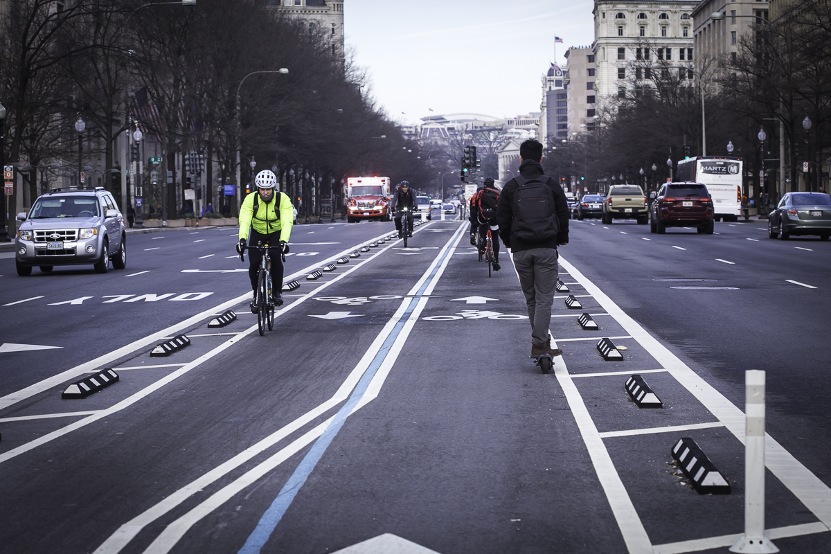
As cities grew and land uses evolved over time, freeways, highways, and other high-volume roads became embedded with their surrounding contexts, whether urban, suburban, or rural. Source: Kittelson & Associates, Inc.
What Starts the Conversation
The discussion on what to do about an old highway rarely begins because a community wakes up one day and decides it’s time to reimagine infrastructure. Most of the time, it begins because the community needs to respond to something that’s gone wrong. These inciting incidents can often be sorted into one of the following categories:
Safety
Safety concerns are frequently the primary driver for change. In many places, longstanding highways were built before modern engineering standards existed—before we knew there was a safer, better way to do things. This resulted in narrow lanes, inconsistent shoulders, difficult crossings, and high speeds, all of which can contribute to crashes. In these cases, the conversation is often framed around fixing the pressing issue.
Shifted Community Priorities
Highways were originally designed to move commuters in vehicles, and in many urban and mixed-use contexts, that singular focus no longer reflects the norm of how people live and travel. Cities increasingly prioritize walkability, bike networks, transit access, economic development, and placemaking because these characteristics better support areas where travel demand is diverse and streets must serve multiple roles beyond just moving cars through as quickly as possible.
This shift in modal priority isn’t always driven by a decline in vehicle travel. In many cases, it’s the opposite: rising or increasingly conflicted vehicle activity in places that were never intended to function solely as high‑volume traffic corridors.
This is true for all types of roadways. For example, Pennsylvania Avenue NW in Washington, DC (“America’s Main Street”) has long functioned as a major corridor across the district; over time, however, increased vehicle traffic and changing travel patterns meant it no longer served any user group especially well. We helped the District Department of Transportation explore alternatives that could rebalance road space and access for pedestrians, cyclists, and transit to better align the street’s design with its civic, cultural, economic, and symbolic roles.
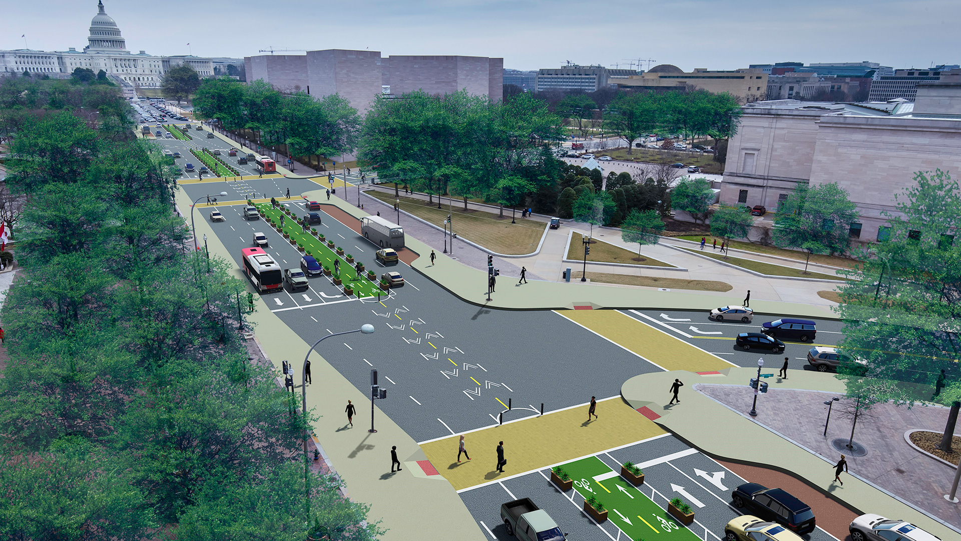
Pennsylvania Avenue NW in Washington, DC used to function as a major corridor across the district, but over time it no longer served any user group well. A team from Kittelson helped the District Department of Transportation explore alternatives that could rebalance road space and access for pedestrians, cyclists, and transit. Source: Kittelson & Associates
Environmental and Health Considerations
A study using 2018 and 2020 census data found that approximately 24% of the U.S. population, or more than 85 million people, now lives near high-volume roadways. With roadways so close to so many, communities are increasingly looking at how the surrounding transportation infrastructure impacts public health. Noise, pollution, heat islands, and limited green space all take a toll on the human body. Research links exposure to high levels of vehicle pollution and traffic noise to an increased risk of health conditions, including heart disease, stroke, and diabetes. Growing awareness of the link between vehicle pollution and worsened health outcomes has prompted cities to look for ways of aligning infrastructure designed decades ago with current public health knowledge.
Previous Community Divisions
Historically, many highways were placed in low‑income or historically disadvantaged communities. The construction of these highways would fracture neighborhoods and displace residents and businesses. For example, when the New Orleans’ Claiborne Expressway was constructed in the 1960s, an estimated 500 homes and 326 Black-owned businesses were displaced in the process. Today’s calls for reinvestment are often sparked by sustained harm made visible over time and affected communities calling for change.
It’s Okay to Start Small
In March 2025, a two-mile stretch of San Francisco’s Great Highway closed so that the roadway could be transformed into a permanent, car‑free park with new public amenities and safer space for walking and biking. The project is also upgrading nearby streets with redesigned intersections and new traffic signals, and repaving to improve safety and manage redirected traffic with the goal of creating a more people‑first coastal network. Dramatic transformations like this one can be powerful symbols of change for their communities. But full teardowns or multimillion-dollar reinventions can be daunting or discouraging to communities.
Dramatic reinventions aren’t the only option for an old highway; approaching a problematic old highway in a purely reactionary way dilutes the full potential of these projects to create lasting, definitional change in communities.
When they’re deployed strategically, smaller changes—some of which involve very little construction—can also make a big impact in improving the functionality of an obsolete highway. You don’t always need to think big to create a big impact. For instance:
- Restriping lanes and other similar traffic-calming features can slow speeds.
- Adding buffered bike lanes can create dedicated infrastructure for people traveling without cars.
- Improving crossings and curb ramps can make difficult crossings easier for pedestrians and improve visibility for drivers.
- Adjusting signal timing can adapt the roadway to its current throughput.
- Adding trees, planters, or green stormwater systems can improve a roadway’s effect on its environment and increase the beauty of its community.
We helped with one of these strategic-yet-meaningful changes in Redmond, Oregon, by providing traffic analysis and design support where SW Veterans Way connects with Highway 126. In March 2026, the City of Redmond began construction to replace traditional highway intersections with roundabouts and connected local streets, with the goal to shift trips off the highway and enable development on formerly highway‑oriented land.
In Rufus, Oregon, a river town of about 250 residents where walking and biking currently mean sharing the road with freight trucks and highway traffic, we worked with the City to develop an Active Transportation Plan and Street Design Standards that identifies 15 prioritized projects, including sidewalks, enhanced crossings, traffic calming, and wayfinding, with early concepts for 1st Street and Main Street to better connect downtown to the waterfront. By pairing community‑driven planning with clear design standards, visuals, and a realistic phased approach, this project gave Rufus a practical path to improve safety and build a more people‑focused street network over time.
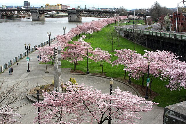
In 1974, the City of Portland replaced Harbor Drive with a 36.59‑acre linear parkway, and in doing so, the City of Portland addressed multiple challenges at once. The park has since been voted one of America’s ten greatest public spaces by the American Planning Association. Source: brx0, Wikimedia Commons.
When Does a Big Transformation Make the Most Sense?
There’s a reason that large-scale repurposing projects make headlines. Whether it is removing elevated highways, capping freeways, or turning obsolete bridges into public spaces, these projects dramatically reshape a city’s relationship with its built environment.
In the case of Tom McCall Waterfront Park, which involved transforming Harbor Drive along the Willamette River in Portland, Oregon into a park, this project was both bold and logical given the city’s conditions at the time. Harbor Drive was originally intended to be a major route through the city, but by the late 1960s, it carried less traffic than projected, was vulnerable to river flooding, and physically severed downtown from the Willamette River. At the same time, regional mobility needs were already being addressed through the construction of I‑405, which gave transportation leaders confidence that removing the riverfront highway would not impede access to the city center.
In 1974, the City of Portland replaced Harbor Drive with a 36.59‑acre linear parkway, and in doing so, the City of Portland addressed multiple challenges at once. It:
- eliminated an underperforming roadway;
- restored public access to the waterfront; and
- created open space that could accommodate flooding rather than fight it.
The City later extended Waterfront Park to the south in 1999, doubling the size of the public open space. The park has since been voted one of America’s ten greatest public spaces by the American Planning Association.
Successful major transformations like Waterfront Park are driven by agencies who deeply understand the people they serve, including their problems and their goals for the future. In Portland, leadership framed the removal of Harbor Drive not as a response to diminished vehicular throughput or its relic stormwater technicals, but as a quality‑of‑life and environmental investment. Extensive engagement, including advisory committees and public dialogue, helped shift the question from “How do we move traffic along the river?” to “What should the riverfront do for the city?”
These transformations maintain a future-focused lens from the start with design and planning. Portland’s leaders recognized that the long‑term value of the corridor was less about its current traffic volumes and more about its role in downtown life decades ahead. Designing the waterfront as adaptable civic infrastructure—able to host major events, accommodate seasonal flooding, and expand over time—required the City to plan for a future community rather than optimize solely for present conditions.
So, You Have an Old Highway. Now What?
Old highways tell the story of a city and how it once moved. What you do with them will shape their communities’ futures. That’s why design for a project—whether big or small—should always follow its purpose. Begin by establishing what you want to achieve by asking questions like:
- Do we want to improve safety for people walking, biking, or riding transit?
- Do we want to support local businesses and redevelopment?
- Do we want to enhance environmental performance and resilience?
- Do we want to reconnect divided neighborhoods?
- Do we want to maintain necessary regional mobility without overwhelming local streets?
From there, remember that repurposing a highway is rarely, if ever, a single moment in time. Often, it’s a process that will unfold over many years. Short-term safety improvement, mid-term street redesigns, and long-term redevelopment can all be part of the same vision.
Repurposing an old highway recognizes that infrastructure, just like the city surrounding it, must evolve to meet the needs of the residents today and tomorrow.
If you need some help thinking through “next steps” for your city’s old highway, we’d love to connect!