August 16, 2022
MetroPlan Orlando-the Metropolitan Planning Organization for Central Florida-uses connected vehicle data from Wejo to identify roadways throughout the region where high speeds may be contributing to more crashes and unsafe conditions for people driving, walking, biking, or moving. This approach allows MetroPlan Orlando to have a snapshot of the entire region at one time, instead of having to investigate each roadway individually. MetroPlan Orlando can also use the same data to answer many other questions (read here how they are using connected vehicle data for signal retiming before/after analyses and to pinpoint where speeding and conflicts are taking place).
The Problem
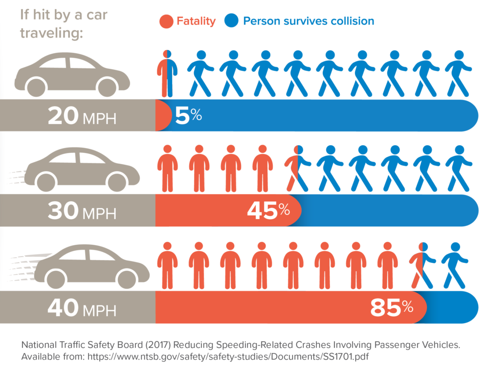
Speeding is a big contributor to crashes and unsafe conditions for people who drive, walk, bike, and roll. People walking and biking are especially vulnerable. According to NACTO, a person hit by a vehicle travelling 50 mph has a 75% chance of dying; compared to a person hit by a vehicle traveling at 32 mph has a 25% chance of dying. Identifying roadways where excessive speeds are common, allows MetroPlan Orlando to effectively implement speed management projects to help keep the community and our most vulnerable users safe.
What We Have Done Historically
Historically it has been difficult to know where the hot spots for speeding are in the region. Transportation professionals have relied on anecdotal evidence or complaints from the community regarding speeding. After identifying a spot that might have a speeding issue, transportation professionals use tubes stretched across the roadway to measure how fast vehicles travel. Collecting speed data with tubes is very effective, but it is hard to know the right location to collect speed data. Some neighbors may be more vocal than others in reporting speeding. On other roads, it may feel like people are speeding more than others. Tube counts also make it incredibly costly to identify speeding on a regional scale. If we wanted to conduct these types of speed studies every half a mile in the MetroPlan Orlando regional area, we would need around 3,200 tube counters which would cost upwards of $1.4M.
In 2020, MetroPlan Orlando first purchased connected vehicle data to use on various projects, including measuring the benefits of signal retiming. Connected vehicle data can also be used to identify roadways where vehicle speeds are high.
What We Can Do Now
In 2020, MetroPlan Orlando first purchased connected vehicle data to use on various projects, including measuring the benefits of signal retiming. Connected vehicle data can also be used to identify roadways with excessive speeding. Data is aggregated for all the vehicles over multiple months to calculate several common speeding statistics for midblock segments along the roadway. Some of the speeding statistics we use to define what roadways have high speeds and rates of speeding include:
- Median speed: half of the vehicles go slower than this, and half of the vehicles go faster than this
- 85th percentile speed: 15% of vehicles go faster than this
- Difference between 85th percentile speed and speed limit: A relative understanding of how much faster drivers are exceeding the speed limit
These statistics allow MetroPlan Orlando to identify some of the roads where high speeds are most prevalent. This data doesn’t replace the detail that transportation professionals can get using tube count data, but it allows us to choose where to collect that tube data much more effectively and without solely relying on the community to let us know where speeding is occurring.
Example Application
In application, it is great to know what roads have a high speed, but MetroPlan Orlando wants to focus on reducing the number of deaths and severe injuries on our roadways. With that in mind, MetroPlan Orlando overlaid the number of crashes that have happened in the last five years with the high-speed roadways. This allows MetroPlan Orlando to identify the roadways where there are high vehicle speeds AND a lot of crashes are occurring. These roads are great candidates to investigate ways to reduce vehicle speeds and contribute to a safer transportation network.
Questions about our methodology or other uses for connected vehicle data? Interested in discussing the relationship between vehicle speeds and safety? Get in touch with us or MetroPlan Orlando!